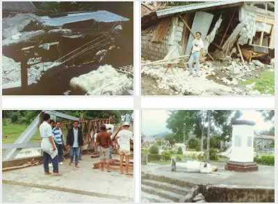
Strongest Earthquake in the Philippines: 10 Most Destructive Tremors in History

The Philippines is no stranger to deadly and destructive earthquakes. Who would ever forget the 7.2-magnitude earthquake that rocked Central Visayas in 2013?
With over 2271 casualties and an astonishing number of damaged historical churches, the earthquake that hit Visayan provinces is one of our history’s strongest. Philippine Institute of Volcanology and Seismology (Phivolcs) Director Renato Solidum said its impact is almost equivalent to “32 Hiroshima bombs.”
However, the Bohol earthquake isn’t the only one that almost brought Filipinos to their knees. In this article, we’ll look back at 10 of the strongest earthquakes in recorded history that put Filipino resiliency to the test.
Table of Contents
At a Glance: Strongest Earthquake in the Philippines
1. Strongest Earthquakes in the Philippines (Summary Table)
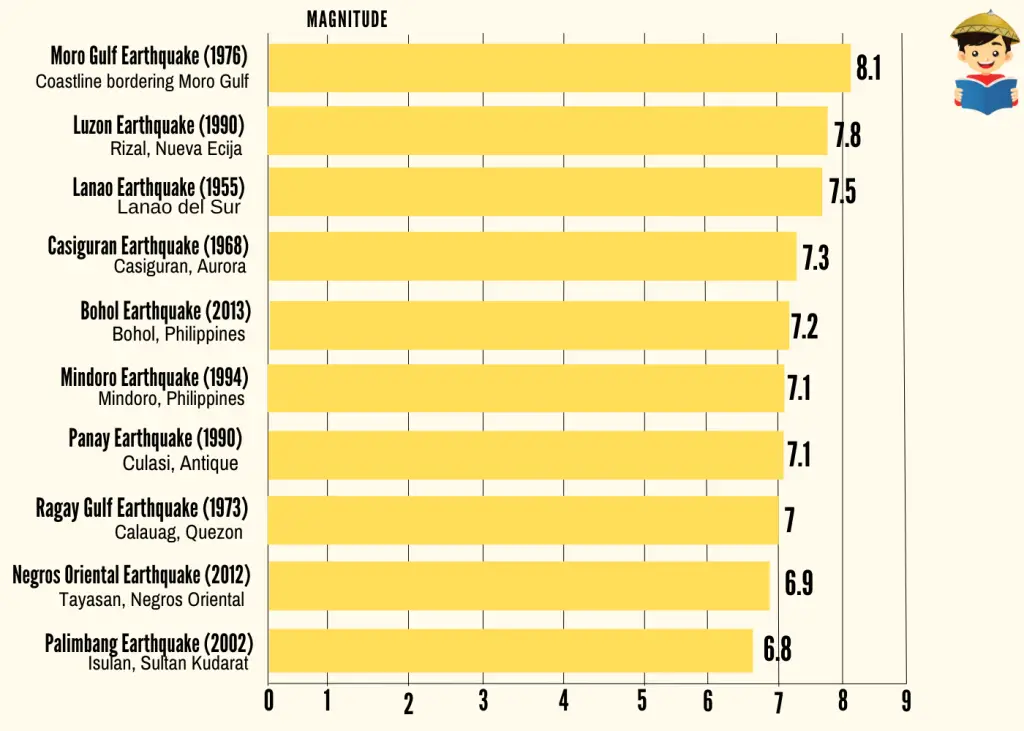
2. Strongest Earthquakes in the Philippines, Ranked According to Magnitude (Graph)
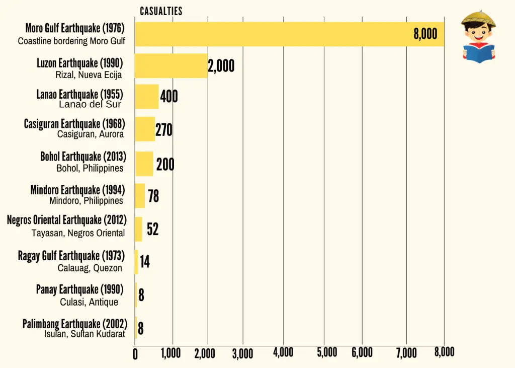
3. Strongest Earthquakes in the Philippines, Ranked According to Number of Casualties (Graph)
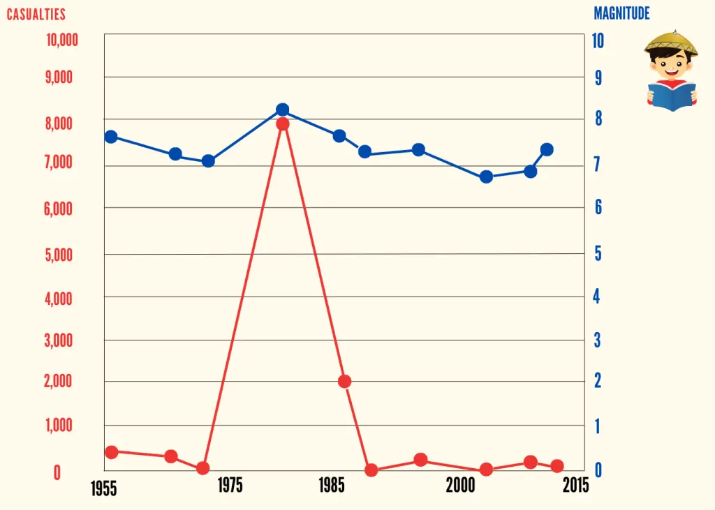
4. Comparing the Magnitude and Number of Casualties of the Philippines’ Strongest Earthquakes (Graph)
What Causes Earthquakes?
An earthquake is formed when plates underneath the Earth’s surface move in different directions. These plates often form friction between each other in areas called faults.
The point in Earth’s interior where the earthquake originates is called the focus. Meanwhile, the point on the earth’s surface above the focus is the epicenter.
Once the impact of the collision becomes significant, it sends a signal in an outward direction, commonly known as seismic waves.
An earthquake can either be naturally-occurring or man-made.
Volcanic earthquakes or shaking due to volcanic eruptions are naturally occurring. Meanwhile, man-made earthquakes include collapse earthquakes (that occur due to the collapse of a mine) and explosion earthquakes (that occur due to the detonation of explosive materials).
Depending on the intensity, earthquakes may cause minor or significant damage to properties. If an earthquake is strong enough, it may lead to other events, such as landslides, tsunamis, or flooding.
Our country lies on a trail along the Pacific Ocean called the “Pacific Ring of Fire2.” This 40,000 km belt is characterized by frequent occurrences of strong earthquakes and volcanic eruptions3. According to PHIVOLCS4, continuous plate movements beneath the countries situated in the belt lead to earthquake production and volcanic eruptions.
Top 10 Strongest Earthquakes Ever Recorded in Philippine History
1. Moro Gulf Earthquake (1976)
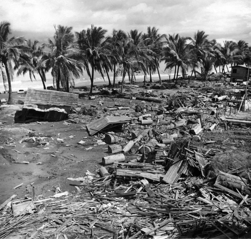
With an 8.1 magnitude5 and a staggering number of casualties, this Mindanao earthquake is officially the strongest and deadliest earthquake in Philippine history.
A tsunami, towering as high as 9 meters, emanated from the epicenter 40 km off the shores of Sultan Kudarat. Because the incident happened in the middle of the night, the inhabitants of the Moro Gulf coastline were left with little to no time to prepare. In the end, an estimated 8,000 people either perished or went missing, and another 90,000 were left homeless because of the properties wiped out by the tragedy.
In the aftermath of the Moro Gulf earthquake and tsunami, President Ferdinand Marcos revised the provision of the National Building Code, requiring structures to be resilient enough to withstand an Intensity 8 earthquake.
2. Luzon Earthquake (1990)
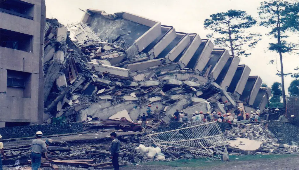
On July 16, 1990, one of the strongest earthquakes to ever strike the country occurred in several areas of Central Luzon and the Cordillera region, with Baguio City bearing the brunt of the massive tremor. This 7.8-magnitude earthquake resulted in almost 2,000 deaths and severe property damage 6.
From the epicenter in Nueva Ecija province, the earthquake rippled through the badly hit areas in Central Luzon, wreaking havoc on numerous properties and trapping people to their deaths. The six-story Christian College of the Philippines in Cabanatuan and the 12-story Hyatt Terraces in Baguio were toppled by the quake. Although many survived due to heroic rescue efforts, some people trapped in the rubble for days didn’t make it due to dehydration.
3. Lanao Earthquake (1955)
This 7.5-magnitude tectonic earthquake that shocked Lanao del Sur on the 1st day of April 1955 resulted in the death of 400 people7. It also destroyed houses and a mosque in the municipality of Tugaya. There are also reports of damaged wharves in Zamboanga and Pagadian.
The earthquake, considered one of the most destructive in Lanao del Sur’s history, is the precursor to the 6.0-magnitude earthquake that hit the province in April 2017. Lanao del Sur is located in one of the most seismically active areas in the country, Central Mindanao, where the western extension of the Mindanao Fault is situated.
4. Casiguran Earthquake (1968)
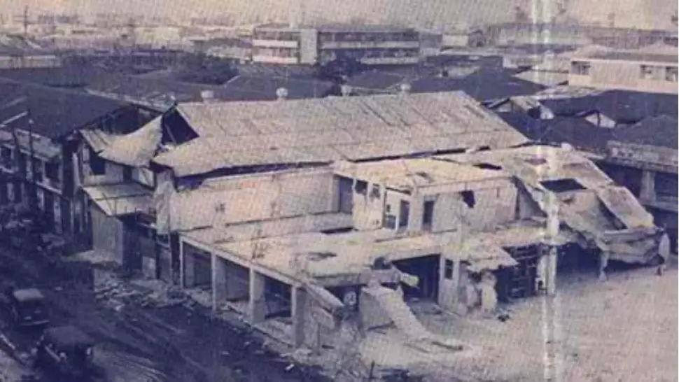
On August 2, 1968, a 7.3-magnitude earthquake hit Casiguran, Aurora, and left 270 people dead8. Before this, the country had never experienced an earthquake with the same intensity and destructive force in the last 20 years.
The most severely damaged was a small part of the Greater Manila Area, particularly Binondo and Escolta, where the total cost of structural damages amounted to several million dollars. Most notable of these damages was the six-story Ruby Tower, which collapsed instantly when the earthquake reached the area, killing and injuring hundreds of people occupying its commercial and residential units.
5. Bohol Earthquake (2013)
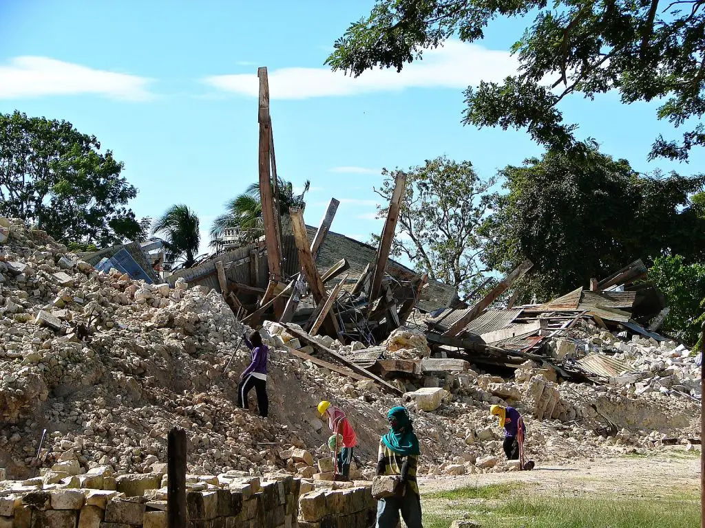
On October 15, 2013, a 7.2-magnitude tremor killed more than 200 people9, destroyed century-old churches.
Although the epicenter was in Bohol, the jolt from the earthquake was felt as far as Southern Mindanao. The catastrophic tremor damaged over 79,000 churches, homes, schools, roads, and public buildings, 14,500 of which were toppled completely10. Worse, it also partially or totally destroyed several health facilities, paralyzing the delivery of essential medicines and health care services for a long time.
A few weeks later, Typhoon Yolanda swept through Central Visayas. One of the most powerful and destructive tropical cyclones ever recorded, Yolanda left thousands of people dead and forced government and international humanitarian groups to divert resources from Bohol to those areas severely affected by the typhoon, which further slowed Bohol’s speed of recovery.
6. Mindoro Earthquake (1994)
https://www.youtube.com/watch?v=qWP9ZBLcqUs
At 3:15 AM on November 15, 199411, a 7.1-magnitude earthquake rocked the residents of Oriental Mindoro in the middle of their sleep.
Five minutes after the main quake, tsunami waves as tall as 8.5 meters (the same height as a three-story building) destroyed 1,530 houses in the coastal areas of Baco Islands and Calapan12.
Residents living near the coast were able to move quickly to higher ground to save themselves from the tsunami. Unfortunately, not everyone was able to survive this tragedy. 78 people were confirmed dead, almost half of which are children who drowned because of the tsunami.
The earthquake also led to liquefaction that damaged roads, bridges, piers, and other infrastructures. The estimated economic damage of the tremor was PHP 156 million.
7. Panay Earthquake (1990)
This 7.1-magnitude quake with an epicenter at Culasi, Antique Province, hit the islands of Panay on June 14, 199013. This catastrophe led to 8 casualties and 41 injuries.
This earthquake toppled 15% of residential houses in Culasi, Antique. Commercial buildings such as warehouses and banks were damaged14. Schools, churches, bridges, and government buildings were also affected. The estimated cost of damage is PHP 30 million.
8. Ragay Gulf Earthquake (1973)
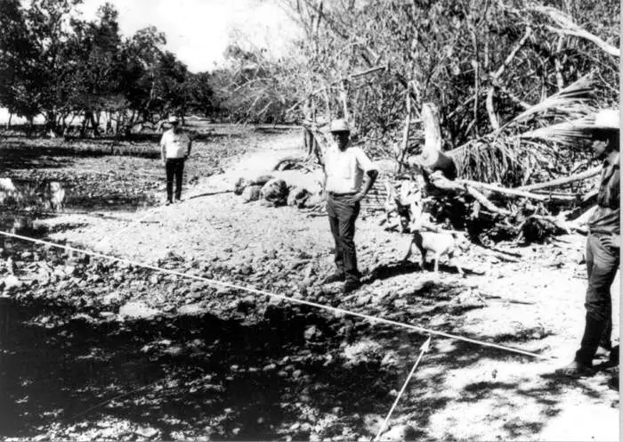
On March 17, 1973, a magnitude seven earthquake wreaked havoc on the town of Calauag, Quezon15. More than 360 residential houses in the town were either totally or partially destroyed. The disaster led to 14 deaths and about 100 injuries. The shaking was felt primarily in Luzon and Northern Visayas.
The earthquake’s epicenter was located along the Ragay Gulf, which lies in the Bicol Peninsula in Southern Luzon. According to a 1974 paper in the Journal of Geological Society of the Philippines16, the vicinity of Ragay Gulf is often the site of destructive earthquakes. Ten significant earthquakes in the region were recorded from 1738 to 1984. Meanwhile, from 1900 to 1973, more than 30 powerful earthquakes along the epicentral area were recorded with a strength of 5-7 magnitude.
Coconuts are one of the prime agricultural goods of the region. The earthquake uprooted and destroyed many young coconut trees, causing a significant decrease in the region’s coconut production.
9. Negros Oriental Earthquake (2012)
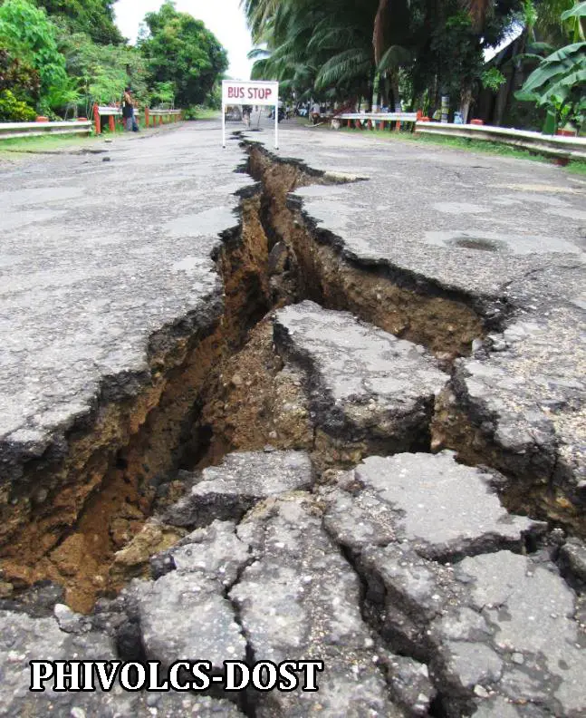
This 6.9-magnitude earthquake that hit Negros Islands and Cebu led to the death of 52 people, at least 29 of which were buried in 30-foot-high soil due to a landslide. Meanwhile, around 112 were injured, and 62 went missing because of the quake.
The tremor triggered five-meter-high tsunami waves that swept Barangay Pisong, Magtalisay, and Martilo in Negros Oriental. PHIVOLCS released a level 2 tsunami alert17 during the earthquake but was canceled after a two-hour observation period during which no peculiar sea level changes occurred. No casualty was recorded due to the tsunami.
Due to the shaking, a staggering 15,787 houses were either completely or partially damaged, seven bridges became impassable, and a road section along Dumaguete North road was filled with rockfalls, cracks, and landslides18.
10. Palimbang Earthquake (2002)
With a magnitude of 6.8 and 8 fatalities, the March 6, 2002 Palimbang earthquake is one of the strongest tremors that hit Mindanao. The quake’s epicenter is located at Isulan, Sultan Kudarat, with the town of Palimbang as the most devastated area19. According to PHIVOLCS, the earthquake was produced by subduction (two tectonic plates converging together) along the Cotabato Trench.
The quake also wreaked havoc on the provinces of Sarangani, North, and South Cotabato, leaving around 7,684 families affected. Damaged infrastructures include public markets, churches, highways, schools, and residential houses.
PHIVOLCS also received a report about the sea receding about 150 meters from the shoreline, indicating an impending tsunami. Eventually, the water returned 75 meters inland.
Tips To Survive an Earthquake
No one wants to be taken by surprise when an earthquake hits. However, it’s impossible to know when the next deadly tremor will occur. It might happen during the most mundane moment of the day or while you’re sleeping.
Here are some tips to keep in mind before, during, and after an earthquake to ensure your safety and of your loved ones when this disaster happens:
1. Before an Earthquake
- Know the nearest evacuation site. If you’re living in a house made of light materials and located along a fault line, it’s best to adhere to your local government’s evacuation guidelines. Thus, it’s essential to know the location of the nearest evacuation site and the safest route.
- Know your home’s “safe spots.” These are the spots where you can take cover in case a quake happens, such as under a sturdy table.
- Create an earthquake plan. This includes delegating to your family members specific tasks that will be accomplished when an earthquake occurs (e.g., where to meet when a quake hits, who will carry the emergency kits, who will call emergency contacts, etc.)
- Prepare an emergency kit. The kit must include ready-to-eat food, bottled water, a first aid kit, a charger, a flashlight, batteries, and important documents.
- Address potential home hazards. Heavy furniture (e.g., shelves and cabinets) and appliances must be secured by strapping or hooking them to the wall. Don’t put heavy items near your home’s exit.
2. During an Earthquake
- Drop, cover, and hold. If possible, do this until the shaking stops. This is the best precaution in case you’re in a high-rise building. Refrain from rushing to the exit (if there are many people) or using an elevator. If there’s no available cover, protect your head and neck using pillows, books, or arms.
- Move away from hazards such as windows, wires, fuel lines, trees, or sinkholes.
- Stop the vehicle if you’re inside, but ensure you’re safe from any hazard.
- Go to the high ground if the shaking continues for more than 20 seconds. A tsunami might ensue because of the persisting quake.
- Walk swiftly if you’re evacuating. This is faster than driving to the evacuation site and will keep you from falling debris.
- Lock your wheelchair if you’re sitting on it.
- If you’re trapped, make noise using metals or any available material. Shouting should be your last resort as it may drain your energy and make you inhale the dust.
c. After an Earthquake
- Prepare for aftershocks. Although these are weaker than the main shaking, they might still impose a risk to your safety and lead to further damage to infrastructure. Thus, stay alert and look out for your loved ones. In case of an aftershock, be ready to practice safety measures just like you did during the main quake.
- Look for cracks in your home’s walls and roof. Don’t forget to check the electrical and water lines as well. Avoid using appliances and turning on the lights if you find broken electrical lines. Report immediately to the local government unit or any concerned agency in case of faulty electrical or water pipes.
- Stay tuned for authorities’ announcements when it’s safe to return home in case you’re in an evacuation site.
References.
- National Risk Reduction Management Council (NDRRMC). (2013). Final Report: Effects of Magnitude 7.2 Sagabayan, Bohol Earthquake. Retrieved from https://ndrrmc.gov.ph/attachments/article/2657/FINAL_REPORT_re_Effects_of_Magnitude_7_2_Sagbayan_Bohol_Earthquake_15OCT-04NOV2013.pdf
- Ring of Fire. Retrieved 12 August 2022, from https://www.britannica.com/place/Ring-of-Fire
- ‘Pacific Ring of Fire’ has always been active —PHIVOLCS. (2020). Retrieved 12 August 2022, from https://www.gmanetwork.com/news/topstories/nation/722258/pacific-ring-of-fire-has-always-been-active-phivolcs/story/
- Information on Disaster Risk Reduction of the Member Countries. Retrieved 12 August 2022, from https://www.adrc.asia/nationinformation.php?NationCode=608&Lang=en&NationNum=14
- 1976 August 17 Mw8.1 Moro Gulf Earthquake. Retrieved 13 August 2022, from https://www.phivolcs.dost.gov.ph/index.php/earthquake/destructive-earthquake-of-the-philippines/2-uncategorised/208-1976-august-17-ms7-9-moro-gulf-earthquake
- Sotelo, Y. (2021). Grim memory of 1990 Luzon quake stays with survivor. Retrieved 13 August 2022, from https://newsinfo.inquirer.net/1460844/grim-memory-of-1990-luzon-quake-stays-with-survivor
- Staff, P. (2017). A Primer on the 12 April 2017 Magnitude 6.0 Lanao del Sur Earthquake. Retrieved 13 August 2022, from https://www.phivolcs.dost.gov.ph/index.php/news/629-a-primer-on-the-12-april-2017-magnitude-6-0-lanao-del-sur-earthquake
- 1968 August 02 Ms7.3 Casiguran Earthquake. Retrieved 13 August 2022, from https://www.phivolcs.dost.gov.ph/index.php/earthquake/destructive-earthquake-of-the-philippines/2-uncategorised/206-1968-august-02-ms7-3-casiguran-earthquake
- National Disaster Risk Reduction and Management Council (NDRRMC). (2013). NDRRMC Update (SitRep No. 35 re Effects of Magnitude 7.2 Sagbayan, Bohol Earthquake). Retrieved from https://web.archive.org/web/20131214193612/http://www.ndrrmc.gov.ph/attachments/article/1108/NDRRMC%20Update%20SitRep%20no.%2035%20re%20Effects%20of%20M7.2%20Bohol%20EQ%2C%203Nov2013%2C%206AM.pdf
- Bohol Earthquake: One year on. (2017). Retrieved 13 August 2022, from https://www.who.int/philippines/news/feature-stories/detail/bohol-earthquake-one-year-on
- Earthquake Engineering Research Institute. (1995). The November 15, 1994, M7.1 Mindoro Island Earthquake in the Philippines. Retrieved from https://www.eeri.org/lfe/pdf/Philippines_MindoroIsland_Insert_Jan95.pdf
- Philippine Institute of Volcanology and Seismology (PHIVOLCS). (2019). Are You Ready? Know What To Do In Case of a Tsunami. Retrieved from https://www.phivolcs.dost.gov.ph/index.php/news/9291-press-release-are-you-ready-know-what-to-do-in-case-of-a-tsunami
- Compilation of Damaging Earthquakes of the Philippines – Panay Earthquake – 14 June 1990. Retrieved 14 August 2022, from https://www.phivolcs.dost.gov.ph/index.php/2-uncategorised/211-1990-june-14-ms7-1-panay-earthquake
- Dela Peña, K. (2022). LIST: Killer earthquakes in the Philippines. Retrieved 14 August 2022, from https://newsinfo.inquirer.net/1635871/list-killer-earthquakes-in-the-philippines
- 1973 March 17 Ms7.0 Ragay Gulf Earthquake. Retrieved 14 August 2022, from https://www.phivolcs.dost.gov.ph/index.php/earthquake/destructive-earthquake-of-the-philippines/2-uncategorised/207-1973-march-17-ms7-0-ragay-gulf-earthquake
- Morante, E. (1974). The Ragay Gulf Earthquake of March 17, 1973, Southern Luzon, Philippines. Journal Of The Geological Society Of The Philippines, 28(2). Retrieved from http://scinet.science.ph/union/Downloads/STII-S-341.51_A2289_1-31_313214.pdf
- Magnitude 6.9 Earthquake Strikes Negos Oriental, Death Toll At Seven. (2012). Retrieved 14 August 2022, from https://www.asianscientist.com/2012/02/topnews/magnitude-6-9-earthquake-negros-oriental-visayas-philippines-phivolc-ndrmmc-feburary-2012/
- National Disaster Risk Reduction and Management Council (NDRRMC). (2012). NDRRMC Update (SitRep No. 22 re Effects of the 6.9 Earthquake in Negros Oriental). Retrieved from https://ndrrmc.gov.ph/attachments/article/1860/Sitrep_No_22_re_Effects_of_6-9_Earthquake_in_Negros_Oriental_as_of_20FEB012_0700H.pdf
- 2002 March 06 Ms6.8 Palimbang Earthquake. Retrieved 14 August 2022, from https://www.phivolcs.dost.gov.ph/index.php/earthquake/destructive-earthquake-of-the-philippines/2-uncategorised/216-2002-march-06-ms6-8-palimbang-earthquake
Written by FilipiKnow
in Facts & Figures, History & Culture, Science and Technology, Travel & Nature
Last Updated
FilipiKnow
FilipiKnow strives to ensure each article published on this website is as accurate and reliable as possible. We invite you, our reader, to take part in our mission to provide free, high-quality information for every Juan. If you think this article needs improvement, or if you have suggestions on how we can better achieve our goals, let us know by sending a message to admin at filipiknow dot net
Copyright Notice
All materials contained on this site are protected by the Republic of the Philippines copyright law and may not be reproduced, distributed, transmitted, displayed, published, or broadcast without the prior written permission of filipiknow.net or in the case of third party materials, the owner of that content. You may not alter or remove any trademark, copyright, or other notice from copies of the content. Be warned that we have already reported and helped terminate several websites and YouTube channels for blatantly stealing our content. If you wish to use filipiknow.net content for commercial purposes, such as for content syndication, etc., please contact us at legal(at)filipiknow(dot)net

